
Introduction
Background
Objectives
Description of Harden Shire
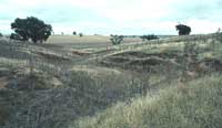
Revegetation Areas
Historical Impacts
Methodology
Literature Review
Data Collection
Product Generation
Use of Herbarium Data
Results - Data Analysis
Herbarium Data
Supplementary Information
Expert Knowledge
Supporting Literature
Species List Collation
Limitations & Scope of Data
Outputs & Outcomes
Conclusions
Recommendations
Acknowledgements
References & Further Reading
Database on-line or download an Excel spreadsheet (large file: 847K)
Appendix A: CPBR Proposal – Species for Vegetation Regeneration
Appendix B: Greening Australia’s Direct Seeding Recommendations List
Appendix C: State Forests of N.S.W. – Trees for Planting Around HardenRegional map showing location of Harden-Murrumburrah
ANH Samples by Collection Dates (108K GIF Map)
ANH Samples by Plant Growth Form (106K GIF Map)
 This
is the final report from the Centre for Plant Biodiversity
Research (CPBR) – a collaborative venture between CSIRO Plant Industry
and the Australian National Botanic Gardens
- as fulfilment of the contract with the Harden Murrumburrah Landcare Group
(HMLG) revegetation project Greening the Grainbelt. The project was supported
by the Natural Heritage Trust through Bushcare.
(Project number BG 0205.99).
This
is the final report from the Centre for Plant Biodiversity
Research (CPBR) – a collaborative venture between CSIRO Plant Industry
and the Australian National Botanic Gardens
- as fulfilment of the contract with the Harden Murrumburrah Landcare Group
(HMLG) revegetation project Greening the Grainbelt. The project was supported
by the Natural Heritage Trust through Bushcare.
(Project number BG 0205.99).
The report consists of this document responding to the milestones as agreed in the contract, an annotated species list of approximately 400 species (in hard copy and on CD-ROM and floppy disk) and this home page on the WWW which also supports an interactive version of the species list.
This project followed the Harden Shire Remnant Vegetation Management Plan (BG0689.96), which revealed only 2.8% remnant vegetation cover. It addresses this severe depletion of native vegetation in the Shire (Jugiong Creek catchment), through addressing areas of high priority listed by the Murrumbidgee Catchment Management Committee in the Murrumbidgee Catchment Action Plan (MCAP). In particular, it targets Key Area No. 4: Vegetation, biodiversity and habitat conservation and enhancement.
Local knowledge of the original native vegetation has been lost or dissipated, so that species lists for planting must be constructed from a range of archival, historical and scientific sources, and expert knowledge. With so little remaining natural vegetation, ground truthing of species occurrence is not an option.
It is anticipated that the development of a picture of the composition of the vegetation of the Harden Shire, and the establishment of scientifically defensible environmentally compatible planting lists will serve as a model for other Landcare areas throughout the country. The project should provide continual encouragement of the community commitment to reversing long term decline of native vegetation.
The Centre for Plant Biodiversity Research (CPBR), working in conjunction with the Harden Murrumburrah Landcare Group (HMLG), agreed to provide botanical guidance for revegetating portions of Harden Shire with native vegetation. Previous species lists provided to the HMLG for planting were regarded as inappropriate (see Appendix C). The Centre’s focus was to make available information on plants native to the region and to provide a recommended list of species, annotated with ecological requirements and cultivation notes, to assist with revegetation programs in the Harden Shire (see Appendix A: CPBR Proposal – Species for Vegetation Regeneration). In part, the project aimed to reconstruct a view of the floristic composition of the original native vegetation.
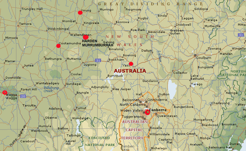
Harden Shire borders the botanical divisions of the NSW South Western and Central Western Slopes, approximately 40km east of Cootamundra and 120km north-west of Canberra, at an elevation of 430m above sea level.
Physical features of a region influence greatly the pattern of vegetation supported and the species composition of any plant community.
The geology of the Harden district is mapped on the Metallogenic Series Sheet SI 55/11 Cootamundra, Geological Survey of NSW, Dept. of Mines, 1976. Harden is positioned centrally in the area of Orogenic Granites.
Rock parent material determines the soil type of any area according to the type of rock, and the amount of weathering exposure it has undergone (Howarth, 1999).
Granite parent material decomposes to give 3 minerals:
Often it is difficult to delineate changes in soil type but some of those that are representative of the Harden area include Lithosols (associated with rocky outcrops), Red Earths (on crests and side slopes), Non Calcic Brown Soils (lower side slopes), Yellow Podzolics (on footslopes), and Solidic Soils (develop on drainage lines).
(Howarth, 1999).
Water tables increase in late winter due to wet soils and rainfall exceeding the rate of evaporation. As most of the plants are slow growing through the winter months and do not require much water, waterlogging occurs in lower areas. This usually results in salts rising to the surface and crystals forming during the hot summer months (Howarth, 1999).
 The
majority of the shire’s land varies from undulating slopes to rolling hills.
The
majority of the shire’s land varies from undulating slopes to rolling hills.
The Bureau of Meteorology website (www.bom.gov.au/climate/data) has the following climate average information for Harden:
Mean Daily Max. temp:
Summer (Jan) = 30.3° C
Autumn (Apr) = 22.3° C
Winter (July) = 12.7° C
Spring (Oct) = 21.4° C
Frosts usually occur from April to October but can sometimes appear as late as the end of November. The annual rainfall is 613.4 mm with the majority falling in the winter months.
 Harden
Shire reflects a mixed farming enterprise, with both crops and stock being used
in an integrated fashion in most cases. Due to historic impacts, some problems
with salinity and weed dominance (such as problems with Scotch Thistle) exist
within the shire. To forestall these problems, Harden Murrumburrah Landcare
has focused on revegetating salinity seepage areas, eroded gullies, and recharge
zones. One of the goals of the project is to identify sets of plants that can
be recommended for revegetation of each of these zones.
Harden
Shire reflects a mixed farming enterprise, with both crops and stock being used
in an integrated fashion in most cases. Due to historic impacts, some problems
with salinity and weed dominance (such as problems with Scotch Thistle) exist
within the shire. To forestall these problems, Harden Murrumburrah Landcare
has focused on revegetating salinity seepage areas, eroded gullies, and recharge
zones. One of the goals of the project is to identify sets of plants that can
be recommended for revegetation of each of these zones.
Salinity seepage areas are identifiable by their tendency to become waterlogged and indicator species such as Juncus australis, Typha domingensis (Narrow-leaved Cumbungi), Typha orientalis, Cynodon dactylon (Couch Grass), and Hordeum marinum (Sea Barley Grass). The planting of tube stock on mounded strips has achieved some success in revegetation of these areas in the Harden Shire. Previous recommendations for species to plant in such areas include: Eucalyptus camaldulensis, E. botryoides, Allocasuarina verticillata (= Casuarina stricta) and Melaleuca decussata (Cross-leaved Honey-myrtle). The spreading salinity areas are lost to cropping and grazing, so there is a strong motivation on the part of the landholders to revegetate these areas.
 Recharge
areas in the Harden Shire are generally either granite or quartz-based with
thin, often poorer, soils. These areas are usually still used for cropping or
grazing, and thus there is less motivation for revegetation, in addition to
the fact that revegetation attempts of these areas have met with a much lower
success rate.
Recharge
areas in the Harden Shire are generally either granite or quartz-based with
thin, often poorer, soils. These areas are usually still used for cropping or
grazing, and thus there is less motivation for revegetation, in addition to
the fact that revegetation attempts of these areas have met with a much lower
success rate.
Gullies are problems in that not only are they subject to extensive erosion, but they also often feed salinity areas. One past practice of controlling runoff in these areas included the planting of tube stock along the drainage lines. This results in a single line of even-aged trees.
The Harden Murrumburrah area was discovered during Hamilton Hume’s journey to the Yass Plains in 1821 and further explored on his journey south to Port Phillip Bay in 1824 (HMHS, 1980, SHUNSW, 1991). Settlement, by squatters, was first recorded in the area in 1830, however, there is evidence to suggest that they had arrived several years earlier (HMHS, 1980).
In 1851 the gold rushes increased the population of the region dramatically, but permanent development was limited until the Robertson Land Act, 1861. This Act enabled people to acquire free-hold title over the land, a far more secure option than the previous system of one year leases (HMHS, 1980). From 1879 the large squatting runs, that had been common in the area, began to break up as the selectors gradually took up the best parts of the land. This era saw the introduction of sheep and agricultural industries into the area (SUNSW, 1991).
 Initially
the development of agriculture was restricted by the amount of labour required
to prepare the land and limited technology. Droughts, a banking crisis and low
wool prices further impeded development until the late 1800’s (HMHS, 1980).
The introduction of machinery such as the harvester in 1893 and multi-furrowed
ploughs enabled an increase in what could be grown as well as the area sown.
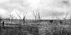
1897 saw the colony’s first wheat surplus (HMHS, 1980). During 1907 the
Cunningham Plains were divided up and sold at public auction. The subdivided
blocks were suitable for a number of farming practices including wheat crops
and stock grazing (CWB King, Licensed surveyor 1907). Other big properties were
gradually subdivided over time with the Soldier Settlement Scheme being the
last major influx of new settlers. Today the average property size is 1500 acres
(~600ha) (HMHS, 1980).
Initially
the development of agriculture was restricted by the amount of labour required
to prepare the land and limited technology. Droughts, a banking crisis and low
wool prices further impeded development until the late 1800’s (HMHS, 1980).
The introduction of machinery such as the harvester in 1893 and multi-furrowed
ploughs enabled an increase in what could be grown as well as the area sown.
1897 saw the colony’s first wheat surplus (HMHS, 1980). During 1907 the
Cunningham Plains were divided up and sold at public auction. The subdivided
blocks were suitable for a number of farming practices including wheat crops
and stock grazing (CWB King, Licensed surveyor 1907). Other big properties were
gradually subdivided over time with the Soldier Settlement Scheme being the
last major influx of new settlers. Today the average property size is 1500 acres
(~600ha) (HMHS, 1980).
Since European settlement in Australia the natural environment has been altered dramatically. Activities such as land clearing for grazing, agriculture and development has resulted in the loss of biodiversity and natural beauty, ecosystem fragmentation, and has exacerbated an increase in erosion and land degradation.
Prior to European settlement, woodlands dominated by box eucalypt species are believed to have covered over 10 million hectares of the wheat-sheep belt of south-eastern Australia (Prober, 1996). Most of these woodlands have now been cleared for cropping or modified by livestock grazing (Brown et al. 1997, Prober 1996). Records of the Cunningham Plains estate reveal that in the early days, the property was timbered with White Box and Yellow Box (Eucalyptus albens and E. melliodora), Apple Box (E. bridgesiana) and "some scattered Gum". However, the vegetation had been ringbarked long before the subdivision, and large areas cleared of vegetation (CWB King licensed surveyor 1907). In some areas the woodlands had also been logged for railway sleepers, fuel and building materials (Brown et al. 1997).
Pre-European floristic composition of the woodlands is largely unknown (Prober, 1997). Understorey components have mostly been eliminated with the remaining overstorey specimens suffering greatly from wind, insect and water-table stresses (Brown et al, 1997). Early explorers and naturalists of the region indicated that the general aspect was "park-like", and that the understorey was dominated by "oat or forest grass" (presumably Kangaroo Grass, Themeda triandra) or covered with "thick grass and gay flowers" (Prober, 1996). Greater detail of the pre-European understorey is not available. The understorey today, where it is not entirely removed for cropping, is generally highly modified (Prober & Thiele, 1995) through grazing, weed invasion and other disturbance.
Some native species/communities exist in remnants that, for historical or economic reasons, have been less intensively grazed than most pastures and never cultivated.
The quality of these remnants is highly variable because the area is surrounded by a matrix of agricultural land (Prober 1996). These remnant areas include cemeteries, rail easements along with nature reserves, state forests, travelling stock reserves and roadsides. The cemeteries and rail easements generally support better quality plant communities because grazing has been minimal since they were established (Prober 1996).
Thomas Austin introduced wild rabbits onto mainland Australia in 1859 near Geelong, Victoria. Since that time they have spread through southern Australia and reach a limit of distribution somewhere north of the Tropic of Capricorn (Williams et al, 1995). Rabbits arrived in NSW about 15 years after their release in Victoria, another 15 years was required before they reached Queensland. The rate of advance varied form 10-15 kilometres per year in the wet and forested country to over 100 kilometres a year in the rangelands (Williams et al, 1995).
It is believed that human changes made the natural environment more suitable for the rabbit. Felled timber provided abundant rabbit harbour and nesting sites in areas where burrows could not be established (Williams et al, 1995). The grazing of perennial grasses by domestic stock made the grasses more nutritious and appealing to rabbits. The introduction of more nutritious annual grasses and forbs of Mediterranean origin, which have a seasonal growth cycle more in tune with the rabbits breeding cycle, also aided the spread of rabbits (Williams et al, 1995).
The initial impact of sheep and rabbits on Australian grasses and forbs was profound. In addition, rabbits are known to ringbark shrubs and fell small trees. Many plant species have disappeared along with their seed banks; and we have no records of what has been lost in many areas (Williams et al, 1995).
Rabbits often graze tree seedlings, and this browsing appears to be on a selective basis. One of the species found in the Harden area, Brachychiton populneus (Kurrajong), faces local extinction wherever rabbits occur. This species, which is used as a fodder tree in parts of Australia, appears to be very palatable to rabbits at all stages of growth. Rabbits have been known to fell and almost entirely consume, Kurrajong trees with trunks up to 18cm in diameter (Williams et al, 1995).
While this aspect of the project was planned to use the collections of the Australian National Herbarium (ANH) as the primary data source, it was important to establish an applicable methodology. The project was in part an experiment to establish the utility of herbarium data in such a study. Thus, a thorough literature search was conducted, and methods from the review were integrated with specific steps required by the objectives.
Previous studies, specifically those that used herbarium data for various research and conservation purposes, were consulted. No article reviewed dealt specifically with the reconstruction of an original flora based on herbarium specimen information. However, some studies have used herbarium data as a subset of larger integrated data searches. In particular, previous work relating to conservation goals were based on herbarium data relating to a specific taxon (e.g., Doig 1996).
The most closely related practice found in the literature were ecogeographic surveys. This is a process of gathering and synthesising taxonomic, geographic and ecological data (Maxted et al. 1995). Surveys often focus on collating data recorded by other plant collectors, rather than obtaining new data, and can be restricted to a literature search and gathering associated data from herbarium specimens and gene bank accessions.
Given that this project was devised to use existing herbarium records to build a picture of the structure of the original vegetation, and that it is impossible to do on-ground surveys with so little natural vegetation remaining, a methodology based loosely on ecogeographic survey techniques was devised.
Various definitions of the target region were delimited during the project in order to include different habitat types and broader or more limited suites of species. Supporting documentation was identified for validating taxa and providing ecological, cultivation, and weed designation information.
Throughout the project local knowledge was incorporated into the analysis and specialists such as botanists, taxonomists, horticulturalists and weed experts were also consulted widely, and enhanced the annotation of the species list.
As indicated in the project proposal, the specimen database of the ANH was interrogated for plant records from the Harden Murrumburrah Landcare area. These searches were based on geographic coordinates and locality names to create the base taxon list. Other taxa were added to the list from literature sources, research projects such as the white box woodland studies with known species lists, and specimen information relating to associated species.
Taxon lists were synthesised using a Microsoft Excel spreadsheet program. Geographic coordinates were used to create maps of ANH specimen collection locations. This web site is used as a delivery mechanism to make the information widely available on this web site.
The Australian National Herbarium maintains a database (ANHSIR) of its herbarium records. This database is part of a much larger integrated database (IBIS) managing plant records for the Centre for Plant Biodiversity Research and the Australian National Botanic Gardens. The ANH maintains one of the best computerised collections nationwide, but only 40% of all 1.4M specimens are databased. This figure compares favourably against Australian herbaria of the same magnitude, and is far greater than most comparable international herbaria. It does however pose some limitations to the use of herbarium data in a study such as this.
Records are added to the database according to priority given to particular botanical families or genera. The ANHSIR database provides the ability to access herbarium records in a variety of ways, including by geographic coordinates, locality, soil type, habit, habitat, or the collector and date of collection. This information is made available to botanists over the internet for research purposes; other herbaria are similarly starting to make their data available in this manner, increasing the information base available to projects such as this.
In this project the ANHSIR database was interrogated to obtain plant records collected around the Harden Shire. A series of latitude-longitude grids were used to identify records from the surrounding area. Since this search would not retrieve records lacking a latitude-longitude determination (the case of many older specimens, when collectors were unaware of the importance of recording complete information), a locality name search was then conducted on all records that did not have a latitude-longitude recorded. Field notes from records (associated data) were used to identify habitat, soils, and associated species. Finally, the database was also used to identify possible remnant areas in the immediate vicinity of the Harden Shire based on field notes from locally collected specimens.
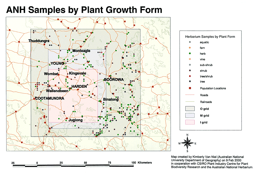
Herbarium data was initially searched based on geographic coordinates using a single latitude and longitude degree grid square (-34� to -35�S latitude and 148� to 149�E longitude; O grid on accompanying maps). The result of this wider search was the first taxon list. Two other grids were chosen within the original grid in order to capture the area that was most representative of Harden’s biophysical and edaphic characteristics. Especially, coordinates were selected to remove specimens that may have been collected in hilly areas that are not representative of the Harden region. This area was defined as –34.19 to –34.92 latitude and 148.15 to 148.69 longitude (M grid on the maps). The final inner grid was designed to capture only the Harden Shire. A slightly larger grid than the actual Shire boundary was used to accommodate for specimen coordinate error. This was defined as –34.37 to –34.86 latitude and 148.15 to 148.61 longitude (I grid).
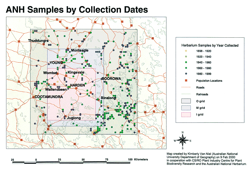 The
accompanying maps show the grids and herbarium specimen locations. These maps
indicate the distribution of ANH specimen locations by year of collection (in
20-year units) and by plant form. In each case the outer grid (O grid) represents
the collections in the broader region sampled; the middle-sized grid (M grid)
defines an area most representative of the biophysical features; the innermost
grid represents the boundaries of the Harden Shire (I grid).
The
accompanying maps show the grids and herbarium specimen locations. These maps
indicate the distribution of ANH specimen locations by year of collection (in
20-year units) and by plant form. In each case the outer grid (O grid) represents
the collections in the broader region sampled; the middle-sized grid (M grid)
defines an area most representative of the biophysical features; the innermost
grid represents the boundaries of the Harden Shire (I grid).
ANH Samples by Collection Dates (108K
GIF Map)
ANH Samples by Plant Growth Form (106K GIF
Map)
Finally, a locality name search was used to find specimens which may have been collected in the area but did not have geographic coordinates assigned. This final search did not reveal any new taxon to add to the list. In addition, associated species listed as occurring with the specimens were used to add taxa to the list.
Herbarium records from the three grids provided the majority of the species listed, which numbered approx. 500 taxa.
The next step was to determine which taxa in the list are native or introduced and whether they would be considered weeds. The noxious weeds list for Harden Shire was used to classify all noxious weeds. These names were added to a separate worksheet within the spreadsheet called "Noxious Plants". The remaining weeds (non-native) were also relocated to a worksheet called "Weeds - Intro". The remaining approx. 400 taxa were placed in the main spreadsheet named "Plant Species List".
 The
species list was then supplemented by the addition of other pertinent information
such as common name, form, habitat, soil type, associated species, available
cultivation information, and any special notes of interest, such as toxicity,
from a variety of literature sources and ANH specimen data.
The
species list was then supplemented by the addition of other pertinent information
such as common name, form, habitat, soil type, associated species, available
cultivation information, and any special notes of interest, such as toxicity,
from a variety of literature sources and ANH specimen data.
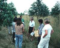
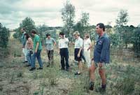
The development of the species lists underwent many iterations and incorporation of data from many sources. Particularly important in this phase was local knowledge and cooperation and input from landowners and experts familiar with the region. Members of the HMLG were especially helpful in annotating the species list, providing locally relevant common names, and building on previous landcare experience.
To supplement and verify the species list, local research, published literature and local reports were used. Prober’s published studies of remnant areas on the western slopes (Prober 1996), Hudson’s (pers.comm.) surveys of roadside vegetation in Young Shire, the Olympic Highway Roadside Vegetation Assessment and Management Guidelines (Stelling 1996), and the Binalong Landcare Report (Brown et al. 1997) were all compared against the taxon list derived from ANH’s database for verification and addition of any other taxa.
The resultant list of approx. 400 species has been collated into a searchable on-line database, as well as an Excel spreadsheet and annotated to indicate:
The list also provides information relating to cultivation and ecological requirements of the listed species, including:
The source of the information by which the species is included in the list is provided. These are primarily the three grids defined to interrogate the ANHSIR database of the Australian National Herbarium – O grid, M grid and I grid – or literature or expertise consulted during the project.
The principal source of data for this project has been the herbarium specimens of the ANH. The most efficient means of accessing the information is via interrogation of the specimen database, however, since only 40% of the specimens in the ANH are databased and available in electronic form, there are likely to be some specimens that would apply to the Harden Shire that were not accessed, as was found with the grass Bothriochloa macra, a widespread NSW slopes species known to grow in the area. Also, since different families and genera have received higher priorities in the database, it is possible that entire genera could be missing from the final taxon list. Some effort was made to address this concern, particularly through consultation with experts.
The milestones as outlined in the CPBR proposal concerning the species for vegetation regeneration for the Greening the Grainbelt project (Appendix A) have been met. The following summarises the products and outcomes of the project:
The following information is provided for the majority of the species listed:
Data accumulated as part of this project has been made available to Environment Australia programs through links with the Environmental Resources & Information Network (ERIN) and its connection to the EA SPRAT (Species, Profiles, Recovery & Threats) database. ERIN maintains a dynamic connection to the herbarium databases and is able to access and use this new information as soon as it is entered.
This project has been an outstanding example of collaboration between a community group, the Harden Murrumburrah Landcare Group and a scientific institution, the Centre for Plant Biodiversity Research. Both partners have benefited in the process of working together, particularly in the area of providing and accessing data in appropriate form for the purposes those on the ground wish to apply the information.
For instance, it was intended originally to extract and publish (hard-copy) a more defined list of selected species for planting recommendations. However, a collaborative decision between the farmers, landmanagers and the scientists was taken to provide the more extensive species list of 400 taxa in electronic form and interactively on the WWW. In that way a farmer would be encouraged to search for a greater diversity of species to plant, and avoid the possibility of a smaller selection of trees becoming vulnerable to disease or insect attack resulting in large scale death of trees in the future.
It is clear that the use of herbarium data to develop a view of past vegetation communities is practical and feasible. As discussed, there are limitations to the data at this time, primarily because all the specimens are not accessible electronically. Furthermore, data from only one major herbarium was available for use in this project; data from other herbaria, while not radically altering the overall picture, would enhance and confirm the confidence in the final result.
Even with these limitations the herbarium data provided the basis to build a scientifically valid species list and a picture of the vegetation structure and the landscape that once occurred in the Harden region. Admittedly with only 2.8% of the natural vegetation remaining in the area, it is not possible to accurately verify the results on the ground, but compatibility with the surrounding region and past historical data corroborate these findings.
The following are recommendations for further follow-up that are significant for the longer term success of this project:
 Much
of the initial interrogation of the ANHSIR database, and the further iteration
of the herbarium specimens not available electronically, was undertaken by a
group of CPBR Botanical Interns in 2000. We would like to acknowledge input
from Nicole Bruce, Monica Rubial and Kimberly Van Niel from Australian National
University, Megan Hewett from Deakin University, Caroline Pampling from Charles
Sturt University, Anarkali Papalkar from University of Newcastle and Purdey
Wong from Sydney University. Kimberley was particularly active in the collation
of earlier versions of the report and in developing the maps.
Much
of the initial interrogation of the ANHSIR database, and the further iteration
of the herbarium specimens not available electronically, was undertaken by a
group of CPBR Botanical Interns in 2000. We would like to acknowledge input
from Nicole Bruce, Monica Rubial and Kimberly Van Niel from Australian National
University, Megan Hewett from Deakin University, Caroline Pampling from Charles
Sturt University, Anarkali Papalkar from University of Newcastle and Purdey
Wong from Sydney University. Kimberley was particularly active in the collation
of earlier versions of the report and in developing the maps.
A number of staff from the CPBR have been involved in the project, Pennie Hohnen carried out database searches, Murray Fagg kept snapping photos and searching historical information, Bob Makinson added a level of expert knowledge to the species list and Anthony Whalen researched, collated and incorporated much of the annotated information on the spreadsheet. Jim Croft provided guidance and vision as to analyses and data handling for friendly delivery, and Judy West liaised with all the players in the project to ensure collaborative effort and to reach the desired outcomes.
Special thanks are due to our partners in this project, the members of the HMLG, and particularly to the Coordinator Louise Hufton for her drive and interest in the project, for coordinating visits to the Harden Shire, and our interactions with other Landcare activists and farmers. We are grateful for contributions from Dick Littlejohn from the Harden Murrumburrah Historical Society, and from Bindi Vanzella (Greening Australia,Wagga) and Ben Stocks (nurseryman) for their local knowledge and input to the species list. Finally, we wish to thank all the farmers who spent their time with us and whose knowledge and commitment to Landcare was both very helpful and impressive.

Anon. 1907, Cunningham Plains Estate, Comprising an Area of 52,624 Acres, Land Sale Catalogue, Sydney.
Australian Network for Plant Conservation 1997, Guidelines for the Translocation of Threatened Plants in Australia, ANPC, Canberra.
Blombery, A.M. 1967, A Guide to Native Australian Plants, Angus and Robertson, Sydney.
Boland, D.J.,et al. 1984, Forest Trees of Australia, 4th ed. Nelson, CSIRO.
Brooker, M.I.H and Kleinig, D 1999, Eucalyptus: an illustrated guide to identification, Reed, Sydney.
Brooker, M.I.H., Connors, J.R. and Slee, A.V. 1997, EUCLID- Eucalypts of southeastern Australia; an interactive identification system CD-ROM. CSIRO Publishing, Melbourne.
Brown, N., Scown, J and Dyson, J 1997, Binalong Landcare Report. Department of Land and Water Conservation.
CPBR 1998, Centre for Plant Biodiversity Research: 1996 – 98 Report CSIRO Plant Industry Communications Group, Canberra.
Doig, R. 1996, The romance of Haloragodendron lucasii Orch., Danthonia 5: 8-9.
Flora of Australia, 1981-2000, AGPS, Canberra - CSIRO Publishing, Melbourne.
Greening Australia, 1999, Local Tree and Shrub Species for the mid Murrumbidgee Catchment flyer, Wagga Wagga, NSW.
Harden, G.J. (ed) 1990-1993, Flora of New South Wales, Vols. 1-4. New South Wales University Press.
Harden Murrumburrah Historical Society, 1980, An outline of the History of the Harden Murrumburrah District. Second Edition.
Holliday, I. and Watton, G. 1978, A Field Guide to Australian Native Shrubs, Rigby, Adelaide.
Howarth, C. 1999, Spring Creek Study Area Report - Draft, September 1999. Department of Land and Water Conservation.
Hudson, K. 2000, Roadside Plant Species lists, part of Superb Parrot Project, Young Shire Council. (unpublished; pers.comm.)
Lazarides, M. and Hince, B. (eds) 1993, CSIRO Handbook of Economic Plants of Australia, CSIRO Publishing, Melbourne.
Lazarides, M., Cowley, K. and Hohnen, P. 1997, CSIRO Handbook of Australian Weeds, CSIRO Publishing, Melbourne.
Maxted, N., Slageren, M.W.van and Rihan, J.R. 1995, Ecogeographic surveys. In ‘Collecting Plant Genetic Diversity. Technical Guidelines’. (eds L. Guarino, R.V. Ramantha & R.Reid). Chapter 14. CAB International.
Prober, S.M.and Thiele, K.R. 1995, ‘Conservation of the Grassy White Box Woodlands: Relative Contributions of Size and Disturbance to Floristic Composition and Diversity of Remnants’, Australian Journal of Botany 43: 349- 366.
Prober, S.M. 1996, ‘Conservation of the Grassy White Box Woodlands: Range wide Floristic Variation & Implications for Reserve Design’, Australian Journal of Botany. 44: 57-77.
School of History, The University of New South Wales 1991, Locality-Bulletin of the Community History Program. Harden-Murrumburrah, NSW. Vol 5, No. 3 November-December 1991.
Southern Slopes Noxious Plants Authority, List of category W1 and W2 noxious plants for Harden, Young, Boorowa, and Yass Shires.
Stelling, F. 1996, Olympic Highway Roadside Vegetation Assessment and Management Guidelines, Olympic Highway Committee.
Tame, T. 1992, Acacias of Southeast Australia, Kangaroo Press, Sydney.
Williams, K., Parter, I., Coman, B., Burley, J. and Braysher, M. 1995, Managing Vertebrate Pests: Rabbits. AGPS, Canberra.
Woolcock, D. 1989, A Field Guide to Native Peaflowers of Victoria and Southeastern Australia, Kangaroo Press, Sydney.
Wrigley, J.W. and Fagg, M. 1996, Australian Native Plants: Propagation, Cultivation and use in Landscaping. 4th Ed. Reed, Sydney.